Posts

2024/07/06 - Severe Weather Expected In Oklahoma On Sunday

Image
8:45 PM CDT | July 6, 2024 - Tomorrow will be an interesting weather day for the Sooner State. We will see an unusually strong disturbance for this time of year. Right now, a cluster or MCS (Meso-Convective System) is taking shape north of the border. This will push southeast through tomorrow morning with the best storm chances to the north of I-40. The current thinking is that the complex of storms will leave an outflow boundary in the state. With ample surface heating during the midday and afternoon hours, the environment along the boundary will be quite favorable for Severe Weather. It is unusual to see a risk for Supercells this time of year so far south... but that is what we will indeed see tomorrow. This is a loop from one of this evening's weather models. It shows the simulated radar from 10:00 PM tonight through 10:00 PM tomorrow night. Keep in mind that this is simply a weather model, and the exact radar conditions will not look exactly like this... It gives you an idea t...
2024/06/04 - LIVE BLOG: Significant Hail & Wind Likely In Oklahoma Through Tonight

Image
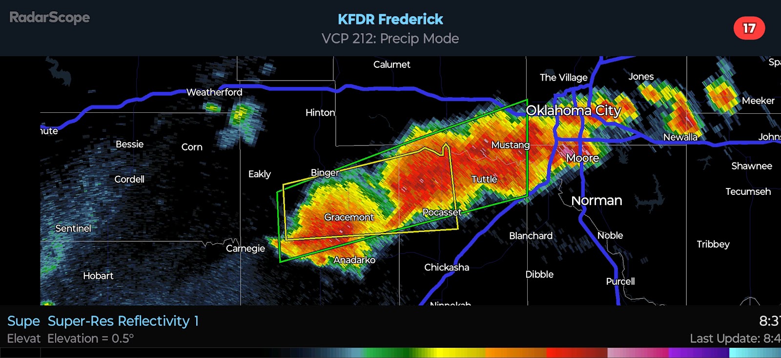
8:40 PM CDT UPDATE - Incredible cluster of supercells south of I-40 are producing Large Hail and Damaging Winds. There are a few areas of rotation that I am watching, especially near Anadarko.  This is a look from where I am, well to the north... Amazing. 5:05 PM CDT UPDATE - The NWS has issued a Severe Thunderstorm Watch for a good portion of Oklahoma. It is in effect until midnight CDT.   4:25 PM CDT UPDATE - Convergence is increasing near the triple point late this afternoon. You can see the agitated cumulus field near Clinton on satellite. The area I have highlighted is where development is likely to occur between 5:00 and 6:00 PM. Surface instability is phenomenal right now across parts of the state. The latest mesoanalysis shows over 7,000 j/kg of SBCAPE near Chickasha. The environment is a powder keg and will be very supportive of Severe Weather near and east of the triple point. The marginal shear will be offset by the presence of such extreme i...

2024/06/04 - Oklahoma City Metro In Prime Location For Severe Weather Today

Image
 10:45 AM CDT | June 4, 2024 - A classic severe weather triple point will set up to the west of Oklahoma City by late afternoon. An outflow boundary from last night's storms swept south and west which will help to keep the dryline from advancing into Central Oklahoma. This places the OKC metro in a very favorable position for Severe Weather. I have drawn up a graphic to illustrate my personal thoughts below. I anticipate storm development near and to the northeast of the triple point between 4:00 and 6:00 PM. Activity will track eastward initially, becoming more southeasterly as updrafts mature and rotate. Instability will be high, particularly along and south of I-40 where surface-based CAPE will exceed 5,000 j/kg. This will offset only marginal shear values for supercells. The result should be similar to what we have seen in recent days - supercells capable of Quarter to Baseball-size Hail and Damaging Winds. There will be the potential for a couple Tornadoes given some backing o...

2024/06/03 - LIVE BLOG: Severe Weather Risk Into The Overnight Hours

Image
10:30 PM CDT UPDATE - Strong Storm development appears to be underway along the I-40 corridor, to the west of OKC. Activity is tracking toward the east right now, but as updrafts mature, they will track more toward the southeast while expanding. Again, Quarter to Baseball-size Hail will be possible with the most intense storms overnight with a secondary risk for Damaging Winds. A conditional risk for Severe Weather will exist tomorrow for parts of the state. More on that in the morning. Good night and stay safe, everyone. 8:55 PM CDT UPDATE - There were a few Severe Thunderstorms in the Texas Panhandle and one strong storm this afternoon in Northwest Oklahoma. They have since dissipated. There appears to be a weak capping inversion located above the surface. Despite the largely favorable environment, the significant severe potential has not been realized. The SPC has maintained a Slight Risk for Central and Southern/Southeast Oklahoma tonight. The primary risk will be Quarter to Baseba...

2024/06/03 - Noteworthy Setup For Oklahoma Unfolding This Morning

Image
 7:40 AM CDT | June 3, 2024 - The weather pattern has not favored anything real "tornadic" for Oklahoma since the last event in late May. Sure we have seen instances of wind damage and large hail, but the risk for tornadoes has been minimal. This may change later today and into tonight. Let me step through it... Right now, we have a Severe Thunderstorm Watch in effect until 12:00 PM for North Central Oklahoma. This is courtesy of the cluster that is producing 60 mph winds and up to quarter-size hail in a few spots. They are pulsing the radars across the region in order to direct the development and outflow. The leading edge of the outflow is being pushed in the direction of Guthrie. As such, I expect storms to weaken as they push toward the OKC and areas to the west. The primary focus for additional development/intensification will be to the north and east of OKC through early afternoon. For the interesting part of this discussion... on the western flank of the residual outfl...

LIVE BLOG: Severe Weather Expected Today (May 25, 2024) Across Kansas, Oklahoma, and North Texas

Image
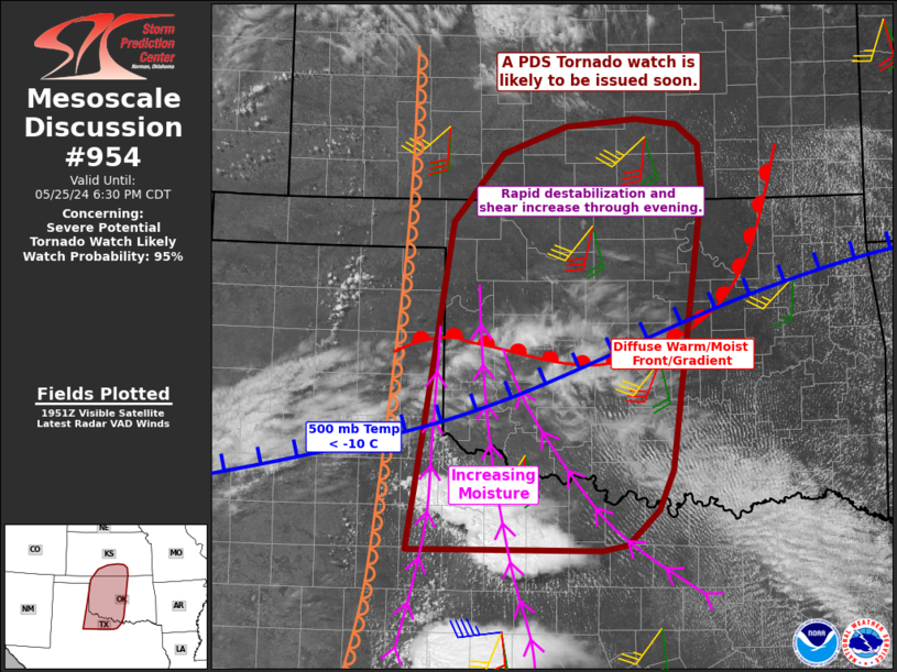
3:10 PM CDT UPDATE - A PDS (Particularly Dangerous Situation) Tornado Watch will be issued soon for Western/Central Oklahoma and adjacent parts of Northwest Texas and Southern Kansas. 12:30 PM CDT UPDATE - The SPC has made some changes to the risk areas with their most recent update, mostly to expand the higher risk probabilities farther south and east. 7:30 AM CDT UPDATE - I am going to be busy today and will not be able to update frequently until this evening, but I wanted to get a couple posts up this morning. There are a few things to mention. The SPC expanded the higher end severe probabilities into North Texas, which is what I was explaining in last night's discussion - that North Texans WILL see a higher risk of Severe Weather this afternoon and evening. The Moderate Risk will likely be extended into far NW/N TX with the Enhanced Risk pushed into the DFW metro. No High Risk has been issued yet for the region, but I feel one will be coming in the next ...

Tornado Outbreak Likely Across Kansas, Oklahoma, and North Texas on Saturday, May 25, 2024

Image
 11:30 PM CDT | May 24, 2024 - It is going to be a very volatile weather day across the Great Plains. Confidence in widespread Severe Weather, some of which will be significant, is high. The SPC Day 2 Outlook which was issued after midday states that Several strong to violent tornadoes, extreme hail, and corridors of widespread wind damage are forecast over parts of the central and southern Plains from late Saturday afternoon into the night. This is very strong wording and they go on to say that "Only reduced confidence in total storm coverage is precluding a High Risk at this time". You can see their official outlook below. Looking at the latest guidance, I believe that the difference with storm coverage among the models is that some are picking up on a disturbance in the jet that moves into Northwest Texas during the afternoon. As this disturbance approaches, it would likely trigger development after 3:00 PM from western North Texas through Southwest Oklahoma. Additional de...